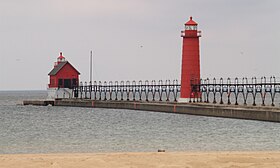
格蘭德港州立公園
外观
| 格蘭德港州立公園 | |
|---|---|
 格蘭德港一座燈塔 | |
公園於密歇根州的位置 | |
| 位置 | 美國密歇根州格蘭德港 |
| 坐标 | 43°03′13″N 86°14′47″W / 43.05361°N 86.24639°W[2] |
| 面积 | 48英畝(19公頃) |
| 海拔 | 591英尺(180米) [2] |
| 建立 | 1920[3] |
| 管理者 | 密歇根州自然資源部 |
| 网站 | 格蘭德港州立公園網站 |
格蘭德港州立公園是一個位於密芝根大河河口南側和格蘭德港港口南側的海岸密芝根湖的州立公園。此公共休閒區佔地48英畝(19公頃),全數由沙灘組成。提供露營場地和海灘,以及格蘭德港南港口入口燈和格蘭德港南港口內燈的景色。[4]
特徵
[编辑]格蘭德港州立公園的西邊是密歇根湖,北邊是格蘭德河,南邊是一個城市海灘。[5]州立公園旁的一個大碼頭有一枝港口的入口燈和格蘭德港南港口內燈。碼頭連接到木板路,向上游延伸至格蘭德港商業區。
歷史
[编辑]格蘭德港州立公園(俗稱「橢圓形」公園)最初是一個35英畝的公共海灘,後來市政府以1,000美元的價格購買了該海灘。1920年,距離碼頭最近的一幅22英畝土地以1美元的價格從城市抵押給州,用作州立公園,而南部的土地保留為城市海灘。[6]因此公園是1919年密歇根州立公園委員會成立後翌年創建的13個公園之一。[7]
活動及設施
[编辑]除了游泳和其他海灘活動外,公園還提供174個露營位置、租賃房屋、釣魚碼頭、野餐區和遊樂場。[4]
參考來源
[编辑]- ^ Grand Haven State Park. IUCN. [April 28, 2020]. (原始内容存档于2018-02-19).
- ^ 2.0 2.1 Grand Haven State Park. Geographic Names Information System. United States Geological Survey.
- ^ When were Michigan state parks and recreation areas established? (PDF). Michigan Department of Natural Resources. [April 28, 2020]. (原始内容存档 (PDF)于2019-04-19).
- ^ 4.0 4.1 Grand Haven State Park. Michigan Department of Natural Resources. [February 18, 2018]. (原始内容存档于2019-12-05).
- ^ City Beach Park (PDF). City of Grand Haven. [July 2, 2018]. (原始内容存档 (PDF)于2020-10-19).
- ^ Riverfront District Self-Guided Walking Tour (PDF). Grand Haven Historic Conservation District Commission. 2014 [July 2, 2018]. (原始内容存档 (PDF)于2020-10-18).
- ^ Michigan DNR celebrates 100 years of state parks (PDF). Michigan Department of Natural Resources: 10–11. [April 28, 2020]. (原始内容存档 (PDF)于2021-01-17).

