漢密爾頓山 (加利福尼亞州)
外觀
| 漢密爾頓山 | |
|---|---|
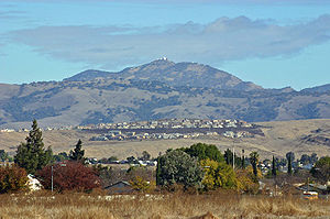
 利克天文台位於漢密爾頓山山頂,山坡上是典型的夏季(旱季)植被 | |
| 別名 | Mount Hamilton Sierra de Santa Isabel[1] |
| 最高點 | |
| 海拔 | 4,265英尺(1,300公尺)[2] |
| 地形突起度 | 93英尺(30米)[3] |
| 座標 | 37°20′30.2″N 121°38′34.2″W / 37.341722°N 121.642833°W [2] |
| 地理 | |
| 位置 | |
| 所屬山脈 | 代阿布洛嶺 |
| 地形圖 | USGS利克天文台 |
| 地質 | |
| 岩石年代 | 上白堊紀 |
| 攀山 | |
| 首次登頂 | 1861年 |
| 最簡路線 | 徒步 |
漢密爾頓山(英語:Mount Hamilton)是美國加利福尼亞州聖克拉拉縣代阿布洛嶺的一座山。這座山高度為4,265英尺(1,300公尺),俯瞰高度城市化的聖克拉拉谷。山頂有世界上第一個永久性有人居住的山頂[4]天文台利克天文台。[5] 1899年發現的小行星452 Hamiltonia以此山命名。在漢密爾頓山的山坡上有發現金雕築巢點。天氣晴朗時,從山頂可以看到塔瑪爾派伊斯山[6]、聖克魯斯山、蒙特雷灣、蒙特雷半島,甚至優勝美地國家公園。[7][8][9]
氣候
[編輯]| 加利福尼亞州漢密爾頓山(氣象站海拔4206英尺) | |||||||||||||
|---|---|---|---|---|---|---|---|---|---|---|---|---|---|
| 月份 | 1月 | 2月 | 3月 | 4月 | 5月 | 6月 | 7月 | 8月 | 9月 | 10月 | 11月 | 12月 | 全年 |
| 歷史最高溫 °F(°C) | 73 (23) |
78 (26) |
77 (25) |
84 (29) |
91 (33) |
94 (34) |
100 (38) |
103 (39) |
98 (37) |
93 (34) |
81 (27) |
76 (24) |
103 (39) |
| 平均高溫 °F(°C) | 48.5 (9.2) |
49.0 (9.4) |
50.1 (10.1) |
55.3 (12.9) |
63.1 (17.3) |
71.4 (21.9) |
78.7 (25.9) |
78.0 (25.6) |
74.2 (23.4) |
65.3 (18.5) |
54.8 (12.7) |
49.0 (9.4) |
61.4 (16.3) |
| 平均低溫 °F(°C) | 36.8 (2.7) |
36.7 (2.6) |
36.7 (2.6) |
39.6 (4.2) |
46.3 (7.9) |
54.4 (12.4) |
63.3 (17.4) |
62.5 (16.9) |
58.4 (14.7) |
50.7 (10.4) |
42.1 (5.6) |
37.1 (2.8) |
47.1 (8.4) |
| 歷史最低溫 °F(°C) | 10 (−12) |
13 (−11) |
17 (−8) |
19 (−7) |
25 (−4) |
28 (−2) |
34 (1) |
37 (3) |
35 (2) |
20 (−7) |
18 (−8) |
7 (−14) |
7 (−14) |
| 平均降水量 英寸(mm) | 4.43 (113) |
3.92 (100) |
3.49 (89) |
2.04 (52) |
0.84 (21) |
0.20 (5.1) |
0.03 (0.76) |
0.07 (1.8) |
0.27 (6.9) |
1.23 (31) |
3.07 (78) |
4.04 (103) |
23.63 (600) |
| 平均降雪量 英寸(cm) | 5.0 (13) |
3.9 (9.9) |
3.8 (9.7) |
2.3 (5.8) |
0 (0) |
0 (0) |
0 (0) |
0 (0) |
0 (0) |
0 (0) |
0.4 (1.0) |
2.3 (5.8) |
17.7 (45) |
| 數據來源:The Western Regional Climate Center[10] | |||||||||||||
參考文獻
[編輯]- ^ Mount Hamilton. Geographic Names Information System. United States Geological Survey. [2009-08-11].
- ^ 2.0 2.1 MT HAMILTON OBS SM DOME 1882. NGS data sheet. 美國測地局.
- ^ Template:Cite pb
- ^ U.S. Geological Survey Publications Warehouse. pubs.usgs.gov. [2015-12-18]. (原始內容存檔於2014-01-08).
- ^ The Building of Lick Observatory. Historical Collections Project. The Link Observatory. [2011-05-08]. (原始內容存檔於2014-11-22).
- ^ 存档副本. [2020-11-20]. (原始內容存檔於2021-04-10).
- ^ Special Project - Bay Nature http://web.archive.org/web/20190708133031/http://www.geoscapesphotography.com/Bay_Nature.html (頁面存檔備份,存於網際網路檔案館) (archived at the Wayback Machine)
- ^ Monterey Peninsula from Mt. Hamilton. [2020-11-20]. (原始內容存檔於2019-01-12).
- ^ Lick Observatory Blog Entry. [2020-11-20]. (原始內容存檔於2018-01-21).
- ^ Seasonal Temperature and Precipitation Information. Western Regional Climate Center. [April 10, 2013]. (原始內容存檔於2021-04-02).
外部連結
[編輯]- Copernicus Peak. SummitPost.org. [2011-05-07].
- Mount Hamilton. The Nature Conservancy. [2011-05-08]. (原始內容存檔於2011-06-15).
- Visiting Lick Observatory. University of California Observatories. [2011-05-08]. (原始內容存檔於2021-02-06).
- Old Hills, New Economies – A Natural History of the Mount Hamilton Ridgelands. BayNature. [2011-05-08]. (原始內容存檔於2012-06-07).
- Silicon Valley Land Conservancy

