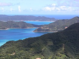
奄美大岛、德之岛、冲绳岛北部及西表岛
外观
此条目可参照日语维基百科相应条目来扩充。 (2021年7月28日) |
| 世界遗产 | |
|---|---|
 | |
| 位置 | |
| 标准 | 自然:(x) |
| 参考编码 | 1574 |
| 登录年份 | 2021年(第44届会议) |
| 面积 | 42,698公顷(164.86平方英里) |
| 缓冲区 | 24,467公顷(94.47平方英里) |
| 坐标 | 28°16′45″N 129°22′42″E / 28.27917°N 129.37833°E |
奄美大岛、德之岛、冲绳岛北部及西表岛(日语:奄美大島、徳之島、沖縄島北部及び西表島)是日本文化遗产,由日本琉球群岛(又称南西诸岛)岛链的四个岛屿组成[1],拥有独特的生态多样性系统,是诸多濒危动植物种的优良栖息地,包括代表着古老谱系、在世界任何地方都没有近亲物种的濒危动物奄美短耳兔和琉球长毛鼠,以及“具有独特进化意义的全球濒危动物”的5种哺乳动物、3种鸟类和3种两栖动物[2][3]。
入选地
[编辑]共有四个岛的五个部分入选世界遗产[4]:
| 序号[5] | 地点 | 所属群岛 | 所在县 | 图片 | 中心点 | 占地面积 (公顷) |
缓冲区面积 (公顷) |
|---|---|---|---|---|---|---|---|
| 1574-001 | 奄美大岛 | 奄美群岛 | 鹿儿岛县 |  |
28°16′45″N 129°22′42″E / 28.27917°N 129.37833°E | 11,640 | 14,663 |
| 1574-002 | 德之岛(a) | 奄美群岛 | 鹿儿岛县 |  |
27°45′48″N 128°58′02″E / 27.76333°N 128.96722°E | 1,724 | 1,813 |
| 1574-003 | 德之岛(b) | 奄美群岛 | 鹿儿岛县 |  |
27°51′48″N 128°55′46″E / 27.86333°N 128.92944°E | 791 | 999 |
| 1574-004 | 冲绳岛北部 | 冲绳群岛 | 冲绳县 |  |
26°43′29″N 128°13′12″E / 26.72472°N 128.22000°E | 7,721 | 3,398 |
| 1574-005 | 西表岛 | 八重山群岛 | 冲绳县 |  |
24°19′34″N 123°48′31″E / 24.32611°N 123.80861°E | 20,822 | 3,594 |
参考资料
[编辑]- ^ Southwest Japan islands added to UNESCO World Heritage list. The Japan Times. 2021-07-27 [2021-07-28]. (原始内容存档于2021-07-28).
- ^ Four Japanese islands added to Unesco World Heritage list. timeout.com. 2021-07-28 [2021-07-28]. (原始内容存档于2021-08-04).
- ^ Four natural and three cultural sites added to UNESCO’s World Heritage List. UNESCO. [2021-07-26]. (原始内容存档于2021-08-28).
- ^ Nomination of Amami-Oshima Island, Tokunoshima Island, Northern Part of Okinawa Island, and Iriomote Island for inscription on the World Heritage List (PDF). Ministry of the Environment: iii. [2021-07-24]. (原始内容存档 (PDF)于2021-07-24).
- ^ Amami-Oshima Island, Tokunoshima Island, Northern part of Okinawa Island, and Iriomote Island : Multiple locations. UNESCO World Heritage Centre. [2021-07-28]. (原始内容存档于2021-07-28).

