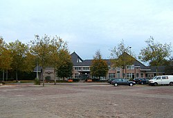
斯塔普霍斯特
外观
| 斯塔普霍斯特 Staphorst | |
|---|---|
| 市镇 | |
 | |
 在上愛塞省的位置 | |
| 坐标:52°39′N 6°13′E / 52.650°N 6.217°E | |
| 國家 | 荷蘭 |
| 省份 | 上愛塞省 |
| 政府[1] | |
| • 行政机构 | Municipal council |
| • 市長 | Theo Segers (CU) |
| 面积[2] | |
| • 总计 | 135.69 平方公里(52.39 平方英里) |
| • 陸地 | 133.99 平方公里(51.73 平方英里) |
| • 水域 | 1.70 平方公里(0.66 平方英里) |
| 海拔[3] | 1 公尺(3 英尺) |
| 人口(2021年)[4] | |
| • 總計 | 17,261人 |
| • 密度 | 129人/平方公里(330人/平方英里) |
| 居民称谓 | Staphorstenaar, Staphorster |
| 时区 | CET(UTC+1) |
| • 夏时制 | CEST(UTC+2) |
| Postcode | 7715, 7950–7955 |
| Area code | 0522 |
| 網站 | www |
斯塔普霍斯特(荷蘭語:Staphorst)是荷蘭的一個市镇,位於荷蘭東部。在行政區劃上,斯塔普霍斯特屬於上愛塞省。斯塔普霍斯特是荷蘭教堂出席率和出生率最高的地區之一[來源請求]。
參考資料
[编辑]- ^ College van B&W [Board of mayor and aldermen]. Gemeente Staphorst. [1 April 2014]. (原始内容存档于2014年4月16日) (荷兰语).
- ^ Kerncijfers wijken en buurten [地区关键统计数字]. 荷蘭中央統計局统计数据. 荷蘭中央統計局. 2013-07-02 [2014-03-12] (荷兰语).
- ^ Postcodetool for 7951DE. Actueel Hoogtebestand Nederland. Het Waterschapshuis. [1 April 2014]. (原始内容存档于2018-12-24) (荷兰语).
- ^ Bevolkingsontwikkeling; regio per maand [Population growth; regions per month]. CBS Statline. CBS. 2022年1月1日 [2022年1月2日] (荷兰语).


