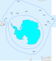
File:WGSRPD Antarctic.svg
外观

此SVG文件的PNG预览的大小:559 × 600像素。 其他分辨率:224 × 240像素 | 448 × 480像素 | 716 × 768像素 | 955 × 1,024像素 | 1,910 × 2,048像素 | 2,580 × 2,767像素。
原始文件 (SVG文件,尺寸为2,580 × 2,767像素,文件大小:133 KB)
文件历史
点击某个日期/时间查看对应时刻的文件。
| 日期/时间 | 缩略图 | 大小 | 用户 | 备注 | |
|---|---|---|---|---|---|
| 当前 | 2015年7月29日 (三) 17:47 |  | 2,580 × 2,767(133 KB) | Peter coxhead | Inner boundary of Subantarctic Islands added |
| 2015年7月29日 (三) 17:37 |  | 2,580 × 2,767(132 KB) | Peter coxhead | Labels corrected | |
| 2015年7月29日 (三) 17:16 |  | 2,580 × 2,767(132 KB) | Peter coxhead | User created page with UploadWizard |
文件用途
以下页面使用本文件:
全域文件用途
以下其他wiki使用此文件:
- en.wikipedia.org上的用途
- Category:Flora of Antarctica
- Category:Biota of Antarctica
- Category:Flora of the Antarctic
- Wikipedia:WikiProject Plants/World Geographical Scheme for Recording Plant Distributions
- User:DexDor/Categorization of organisms by geography
- Category:Flora of the subantarctic islands
- Category:Lichens of Antarctica
- Category:Lichens of the Antarctic
- Category:Lichens of the subantarctic islands
- es.wikipedia.org上的用途
- hr.wikipedia.org上的用途
- species.wikimedia.org上的用途
- tr.wikipedia.org上的用途
- Kategori:Antarktika faunası
- Kategori:Antarktika'da doğa tarihi
- Kategori:Subantarktik
- Kategori:Antarktika florası
- Kategori:Antarktika biyotası
- Kategori:Subantarktik adaları faunası
- Kategori:Antarktik biyocoğrafik bölgesi
- Kategori:Antarktik biyocoğrafik bölgesi biyotası
- Kategori:Antarktik biyocoğrafik bölgesi faunası
- Kategori:Subantarktik adaları florası
- Kategori:Antarktik biyocoğrafik bölgesi florası
- Kategori:Antarktika kuşları
- Kategori:Antarktika omurgalıları

