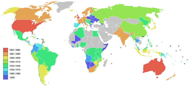
File:Salvation army world map.PNG
外观

本预览的尺寸:800 × 370像素。 其他分辨率:320 × 148像素 | 640 × 296像素 | 1,357 × 628像素。
原始文件 (1,357 × 628像素,文件大小:64 KB,MIME类型:image/png)
文件历史
点击某个日期/时间查看对应时刻的文件。
| 日期/时间 | 缩略图 | 大小 | 用户 | 备注 | |
|---|---|---|---|---|---|
| 当前 | 2008年5月20日 (二) 11:28 |  | 1,357 × 628(64 KB) | Ictys~commonswiki | And Greec |
| 2008年5月20日 (二) 11:24 |  | 1,357 × 628(64 KB) | Ictys~commonswiki | New version with Namibia and Mali | |
| 2006年2月26日 (日) 14:28 |  | 1,357 × 628(37 KB) | Roke~commonswiki | Map showing the Worldwide expansion of the Salvation Army. Since the map refers to locations over a 140 year period, some countries may not correspond exactly to the area of the original historic country where the Salvation army was originally founded in. |
文件用途
以下页面使用本文件:
全域文件用途
以下其他wiki使用此文件:
- als.wikipedia.org上的用途
- de.wikipedia.org上的用途
- de.wikibooks.org上的用途
- en.wikipedia.org上的用途
- et.wikipedia.org上的用途
- fi.wikipedia.org上的用途
- gl.wikipedia.org上的用途
- hu.wikipedia.org上的用途
- id.wikipedia.org上的用途
- pl.wikipedia.org上的用途
- pt.wikipedia.org上的用途
- ro.wikipedia.org上的用途


