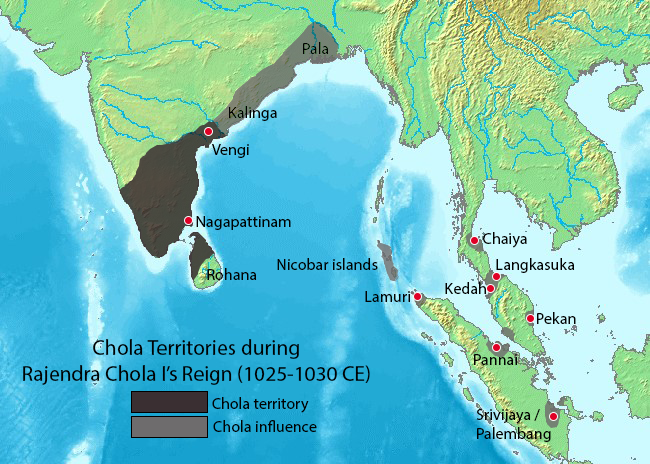
File:Rajendra territories cl.png
外观
Rajendra_territories_cl.png (650 × 464像素,文件大小:504 KB,MIME类型:image/png)
文件历史
点击某个日期/时间查看对应时刻的文件。
| 日期/时间 | 缩略图 | 大小 | 用户 | 备注 | |
|---|---|---|---|---|---|
| 当前 | 2022年12月27日 (二) 21:44 |  | 650 × 464(504 KB) | Verosaurus | Revised based on https://commons.wikimedia.org/wiki/File:Rajendra_map_new.svg and https://en.wikipedia.org/wiki/Talk:Chola_dynasty#Maps . Pegu isn't included since it's not on the original map, furthermore, it isn't mentioned in the Tanjore inscription. |
| 2006年6月25日 (日) 13:40 |  | 482 × 430(119 KB) | Nicke L | {{Information| |Description= == Summary == Map showing the extent of the Chola empire during Rajendra Chola I. Source of map: http://www2.demis.nl/mapserver/mapper.asp (mention : "Disclaimer: With this statement DEMIS BV grants you permission to freely c |
文件用途
以下页面使用本文件:
全域文件用途
以下其他wiki使用此文件:
- ast.wikipedia.org上的用途
- en.wikipedia.org上的用途
- es.wikipedia.org上的用途
- fr.wikipedia.org上的用途
- ko.wikipedia.org上的用途
- lt.wikipedia.org上的用途
- nl.wikipedia.org上的用途
- sq.wikipedia.org上的用途
- sv.wikipedia.org上的用途
- ta.wikipedia.org上的用途
- zh-yue.wikipedia.org上的用途


