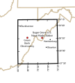
File:National Radio Quiet Zone.svg
外观

此SVG文件的PNG预览的大小:541 × 600像素。 其他分辨率:216 × 240像素 | 433 × 480像素 | 692 × 768像素 | 923 × 1,024像素 | 1,847 × 2,048像素 | 679 × 753像素。
原始文件 (SVG文件,尺寸为679 × 753像素,文件大小:121 KB)
文件历史
点击某个日期/时间查看对应时刻的文件。
| 日期/时间 | 缩略图 | 大小 | 用户 | 备注 | |
|---|---|---|---|---|---|
| 当前 | 2020年10月6日 (二) 03:00 |  | 679 × 753(121 KB) | Arlo Barnes | four years belated update |
| 2009年11月17日 (二) 04:26 |  | 679 × 753(529 KB) | Denelson83 | Fix mis-labelling of 38°00'N as "38°30'" | |
| 2009年10月28日 (三) 08:17 |  | 679 × 753(524 KB) | Spellcheck | Converted text to outlines | |
| 2009年10月28日 (三) 08:14 |  | 679 × 753(355 KB) | Spellcheck | Increased font size for better thumbnail. | |
| 2009年10月28日 (三) 07:36 |  | 679 × 753(355 KB) | Spellcheck | {{Information |Description={{en|1=The location of the United States National Radio Quiet Zone and major locations within it.}} |Source=Derivative of public-domain http://en.wikipedia.org/wiki/File:Map_of_current_Interstates.svg Information from http://www |
文件用途
以下页面使用本文件:
全域文件用途
以下其他wiki使用此文件:
- ar.wikipedia.org上的用途
- de.wikipedia.org上的用途
- en.wikipedia.org上的用途
- fa.wikipedia.org上的用途
- fr.wikipedia.org上的用途
- it.wikipedia.org上的用途
- ja.wikipedia.org上的用途
- pt.wikipedia.org上的用途
- ru.wikipedia.org上的用途
- uk.wikipedia.org上的用途
- www.wikidata.org上的用途

