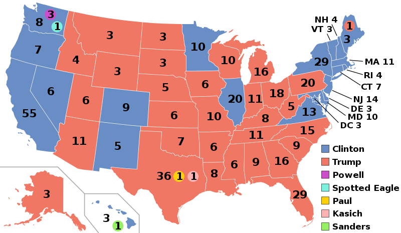
File:ElectoralCollege2016.svg
外观

此SVG文件的PNG预览的大小:800 × 465像素。 其他分辨率:320 × 186像素 | 640 × 372像素 | 1,024 × 595像素 | 1,280 × 744像素 | 2,560 × 1,488像素 | 1,020 × 593像素。
原始文件 (SVG文件,尺寸为1,020 × 593像素,文件大小:30 KB)
文件历史
点击某个日期/时间查看对应时刻的文件。
| 日期/时间 | 缩略图 | 大小 | 用户 | 备注 | |
|---|---|---|---|---|---|
| 当前 | 2020年11月27日 (五) 03:22 |  | 1,020 × 593(30 KB) | Politicsfan4 | Updated placement of ME-2's electoral vote for consistency with 2020 map |
| 2020年8月5日 (三) 01:22 |  | 1,020 × 593(30 KB) | Nojus R | Reverted to version as of 07:42, 13 January 2019 (UTC) it looks so weird when every other map uses a different font | |
| 2019年12月10日 (二) 19:31 |  | 1,020 × 593(30 KB) | IagoQnsi | switching font to Arial, as it looks less-ugly in the server-side rendering // Editing SVG source code using c:User:Rillke/SVGedit.js | |
| 2019年1月13日 (日) 07:42 |  | 1,020 × 593(30 KB) | Newfraferz87 | (minor) | |
| 2018年11月20日 (二) 02:50 |  | 1,020 × 593(30 KB) | Newfraferz87 | *DC | |
| 2018年11月20日 (二) 02:35 |  | 1,020 × 593(30 KB) | Newfraferz87 | Simplify further: coordinates & fills, following this | |
| 2017年1月18日 (三) 14:16 |  | 1,020 × 593(36 KB) | Newfraferz87 | Shrink size using relative line coordinates. Thanks for the border corrections. | |
| 2017年1月17日 (二) 09:20 |  | 1,020 × 593(43 KB) | Karlfk | Better borderlines, esp. OH/WV/PA triangle or ID/MT border | |
| 2017年1月12日 (四) 03:14 |  | 1,020 × 593(36 KB) | PalmerTheGolfer | Reverted to version as of 00:56, 3 January 2017 (UTC) Font of numbers and State line consistency with prior elections more important than a non-existent Libretarian faithless elector change | |
| 2017年1月10日 (二) 22:50 |  | 1,020 × 593(36 KB) | Maproom | Changed font to Liberation Sans, in the hope of avoiding the problem of "Eagle" extending off the end of the image |
文件用途
以下5个页面使用本文件:
全域文件用途
以下其他wiki使用此文件:
- af.wikipedia.org上的用途
- ang.wikipedia.org上的用途
- ar.wikipedia.org上的用途
- arz.wikipedia.org上的用途
- az.wikipedia.org上的用途
- be.wikipedia.org上的用途
- bg.wikipedia.org上的用途
- bn.wikipedia.org上的用途
- bs.wikipedia.org上的用途
- ca.wikipedia.org上的用途
- cdo.wikipedia.org上的用途
- ckb.wikipedia.org上的用途
- cs.wikipedia.org上的用途
- cy.wikipedia.org上的用途
- da.wikipedia.org上的用途
- de.wikipedia.org上的用途
- diq.wikipedia.org上的用途
- dty.wikipedia.org上的用途
- el.wikipedia.org上的用途
- en.wikipedia.org上的用途
- Electoral vote changes between United States presidential elections
- List of United States presidential election results by state
- Presidency of Barack Obama
- 2016 United States presidential election
- United States presidential election
- 2016 Democratic Party presidential candidates
- 2016 Democratic Party presidential primaries
- 2016 Republican Party presidential candidates
- 2016 Republican Party presidential primaries
- 2016 United States elections
- User:ArcMachaon/sandbox
- User:Mandruss/sandbox
查看此文件的更多全域用途。


