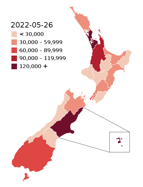
File:COVID-19 Outbreak Cases in New Zealand (DHB Totals).svg
外观

此SVG文件的PNG预览的大小:460 × 599像素。 其他分辨率:184 × 240像素 | 369 × 480像素 | 590 × 768像素 | 787 × 1,024像素 | 1,573 × 2,048像素 | 650 × 846像素。
原始文件 (SVG文件,尺寸为650 × 846像素,文件大小:138 KB)
文件历史
点击某个日期/时间查看对应时刻的文件。
| 日期/时间 | 缩略图 | 大小 | 用户 | 备注 | |
|---|---|---|---|---|---|
| 当前 | 2022年5月26日 (四) 03:55 |  | 650 × 846(138 KB) | Air55 | Updated totals as of 26 May 2022 |
| 2022年4月3日 (日) 02:25 |  | 650 × 846(138 KB) | Air55 | updated totals as of 2 April 2022 | |
| 2022年3月17日 (四) 07:47 |  | 650 × 846(138 KB) | Air55 | updated totals | |
| 2022年3月8日 (二) 00:48 |  | 650 × 846(138 KB) | Air55 | case totals + scale update | |
| 2022年3月6日 (日) 02:16 |  | 650 × 846(138 KB) | Air55 | updated case totals | |
| 2022年3月2日 (三) 01:42 |  | 650 × 846(138 KB) | Air55 | updated ranges | |
| 2022年3月2日 (三) 01:09 |  | 650 × 846(138 KB) | Air55 | 02 March 2022 totals | |
| 2022年3月1日 (二) 04:43 |  | 650 × 846(138 KB) | Air55 | Redid map. Legend now features in map for ease of updating across all pages, colour bins updated | |
| 2022年3月1日 (二) 03:06 |  | 650 × 846(135 KB) | Air55 | updated as of 28 Feb. will be looking at making a new version of this map in light of the rapidly rising cases | |
| 2022年1月29日 (六) 00:36 |  | 650 × 846(135 KB) | Air55 | Updated case totals for 28 January 2022. Colours changed for BOP, Lakes, and Canterbury DHBs. |
文件用途
以下页面使用本文件:
全域文件用途
以下其他wiki使用此文件:
- de.wikipedia.org上的用途
- en.wikipedia.org上的用途
- es.wikipedia.org上的用途
- fa.wikipedia.org上的用途
- fr.wikipedia.org上的用途
- he.wikipedia.org上的用途
- id.wikipedia.org上的用途
- ko.wikipedia.org上的用途
- ms.wikipedia.org上的用途
- nl.wikipedia.org上的用途
- ru.wikipedia.org上的用途
- simple.wikipedia.org上的用途
- sq.wikipedia.org上的用途
- th.wikipedia.org上的用途
- uk.wikipedia.org上的用途
- uz.wikipedia.org上的用途
- vi.wikipedia.org上的用途
- zh-yue.wikipedia.org上的用途


