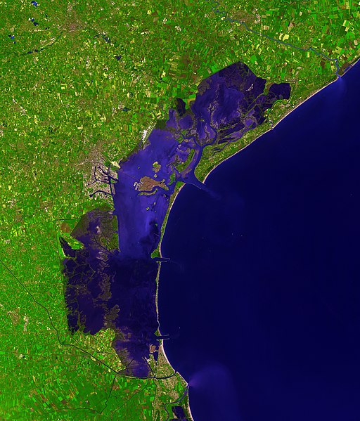
File:Venice Lagoon December 9 2001.jpg
外觀

預覽大小:512 × 599 像素。 其他解析度:205 × 240 像素 | 410 × 480 像素 | 656 × 768 像素 | 875 × 1,024 像素 | 1,750 × 2,048 像素 | 3,580 × 4,189 像素。
原始檔案 (3,580 × 4,189 像素,檔案大小:11.35 MB,MIME 類型:image/jpeg)
檔案歷史
點選日期/時間以檢視該時間的檔案版本。
| 日期/時間 | 縮圖 | 尺寸 | 使用者 | 備註 | |
|---|---|---|---|---|---|
| 目前 | 2006年12月7日 (四) 15:41 |  | 3,580 × 4,189(11.35 MB) | AlMare | Cropped |
| 2006年11月13日 (一) 11:46 |  | 3,598 × 4,200(11.09 MB) | AlMare | ||
| 2006年11月10日 (五) 14:14 |  | 3,598 × 4,200(8.42 MB) | AlMare | {{en|This picture of the en:Venetian Lagoon was taken by ASTER (Advanced Spaceborne Thermal Emission and Reflection Radiometer), an imaging instrument flying on Terra, a satellite part of NASA's Earth Observing System |
檔案用途
下列4個頁面有用到此檔案:
全域檔案使用狀況
以下其他 wiki 使用了這個檔案:
- ar.wikipedia.org 的使用狀況
- ast.wikipedia.org 的使用狀況
- ba.wikipedia.org 的使用狀況
- be.wikipedia.org 的使用狀況
- bg.wikipedia.org 的使用狀況
- bn.wikipedia.org 的使用狀況
- bn.wikibooks.org 的使用狀況
- br.wikipedia.org 的使用狀況
- ca.wikipedia.org 的使用狀況
- cs.wikipedia.org 的使用狀況
- cy.wikipedia.org 的使用狀況
- de.wikipedia.org 的使用狀況
- de.wiktionary.org 的使用狀況
- el.wikipedia.org 的使用狀況
- en.wikipedia.org 的使用狀況
- en.wiktionary.org 的使用狀況
- eo.wikipedia.org 的使用狀況
- eo.wikivoyage.org 的使用狀況
- et.wikipedia.org 的使用狀況
- fa.wikibooks.org 的使用狀況
- fi.wikipedia.org 的使用狀況
- fi.wiktionary.org 的使用狀況
- frr.wikipedia.org 的使用狀況
- fr.wikipedia.org 的使用狀況
- fy.wikipedia.org 的使用狀況
- gl.wikipedia.org 的使用狀況
- hi.wikipedia.org 的使用狀況
- hr.wikipedia.org 的使用狀況
- hu.wikipedia.org 的使用狀況
檢視此檔案的更多全域使用狀況。


