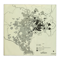
File:US Strategic Bombing of Tokyo 1944-1945.png
外觀

預覽大小:600 × 600 像素。 其他解析度:240 × 240 像素 | 480 × 480 像素 | 768 × 768 像素 | 1,024 × 1,024 像素 | 2,048 × 2,048 像素 | 3,072 × 3,072 像素。
原始檔案 (3,072 × 3,072 像素,檔案大小:2.57 MB,MIME 類型:image/png)
檔案歷史
點選日期/時間以檢視該時間的檔案版本。
| 日期/時間 | 縮圖 | 尺寸 | 使用者 | 備註 | |
|---|---|---|---|---|---|
| 目前 | 2014年3月4日 (二) 01:59 |  | 3,072 × 3,072(2.57 MB) | Mopenstein | Apparently I uploaded the incorrect file last time. This is the correct repaired image |
| 2014年3月4日 (二) 01:57 |  | 3,072 × 3,072(2.57 MB) | Mopenstein | Fixed patch of blurred image increasing the definition | |
| 2009年10月5日 (一) 21:11 |  | 3,072 × 3,072(2.79 MB) | Andy Anderson | {{Information |Description={{en|1="Effects of air attack on urban complex Tokyo-Kawasaki-Yokohama". Map of the U.S. strategic bombing campaign on Tokyo from November 29, 1944 - March 9, 1945 Image extracted from PDF of original document and saved as PNG, |
檔案用途
下列2個頁面有用到此檔案:
全域檔案使用狀況
以下其他 wiki 使用了這個檔案:
- azb.wikipedia.org 的使用狀況
- ca.wikipedia.org 的使用狀況
- cs.wikipedia.org 的使用狀況
- de.wikipedia.org 的使用狀況
- en.wikipedia.org 的使用狀況
- eu.wikipedia.org 的使用狀況
- fr.wikipedia.org 的使用狀況
- id.wikipedia.org 的使用狀況
- ja.wikipedia.org 的使用狀況
- ko.wikipedia.org 的使用狀況
- no.wikipedia.org 的使用狀況
- vi.wikipedia.org 的使用狀況
- www.wikidata.org 的使用狀況


