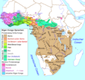
File:Niger-Kongo-Karte.png
外观

本预览的尺寸:635 × 599像素。 其他分辨率:254 × 240像素 | 509 × 480像素 | 814 × 768像素 | 1,207 × 1,139像素。
原始文件 (1,207 × 1,139像素,文件大小:138 KB,MIME类型:image/png)
文件历史
点击某个日期/时间查看对应时刻的文件。
| 日期/时间 | 缩略图 | 大小 | 用户 | 备注 | |
|---|---|---|---|---|---|
| 当前 | 2018年3月15日 (四) 20:57 |  | 1,207 × 1,139(138 KB) | Maphobbyist | South Sudan border |
| 2015年7月4日 (六) 00:56 |  | 1,207 × 1,139(137 KB) | Kwamikagami | rm. Khoisan | |
| 2007年10月28日 (日) 20:29 |  | 1,207 × 1,139(76 KB) | Ulamm | ||
| 2007年10月26日 (五) 08:52 |  | 1,207 × 1,139(77 KB) | Ulamm | == Summary == {{Information |Description=Map of the Niger-Congo-languages und Khoi-San-languages in Afrika / Karte der Niger-Kongo-Sprachen und Khoisan-Sprachen in Afrika |Source=Relaunch (especially larger letters) of [[:de:Image:Karte_der_Niger-Kongo-Sp |
文件用途
没有页面使用本文件。
全域文件用途
以下其他wiki使用此文件:
- bg.wikipedia.org上的用途
- de.wikipedia.org上的用途
- eo.wikipedia.org上的用途
- frr.wikipedia.org上的用途
- ilo.wikipedia.org上的用途
- lv.wikipedia.org上的用途
- pt.wikipedia.org上的用途

