File:Hanover1720.png
外观

本预览的尺寸:707 × 600像素。 其他分辨率:283 × 240像素 | 566 × 480像素 | 906 × 768像素 | 1,208 × 1,024像素 | 2,500 × 2,120像素。
原始文件 (2,500 × 2,120像素,文件大小:537 KB,MIME类型:image/png)
文件历史
点击某个日期/时间查看对应时刻的文件。
| 日期/时间 | 缩略图 | 大小 | 用户 | 备注 | |
|---|---|---|---|---|---|
| 当前 | 2009年11月24日 (二) 22:01 |  | 2,500 × 2,120(537 KB) | The Illusional Ministry | Changed colours |
| 2009年11月24日 (二) 22:00 |  | 2,500 × 2,120(537 KB) | The Illusional Ministry | Changed colours | |
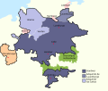
| 2007年8月20日 (一) 07:56 |  | 2,500 × 2,120(592 KB) | DrKay | {{Information |Description=Sketch map of the state of Hanover, c.1720 showing territorial acquisitions and some neighbouring states and imperial cities; drawn in Adobe Photoshop by hand using a pen tablet. |Source=self-made |Date= |Author= [[User:DrKierna |
文件用途
全域文件用途
以下其他wiki使用此文件:
- ar.wikipedia.org上的用途
- be.wikipedia.org上的用途
- ckb.wikipedia.org上的用途
- cs.wikipedia.org上的用途
- da.wikipedia.org上的用途
- el.wikipedia.org上的用途
- en.wikipedia.org上的用途
- es.wikipedia.org上的用途
- et.wikipedia.org上的用途
- fr.wikipedia.org上的用途
- he.wikipedia.org上的用途
- hu.wikipedia.org上的用途
- it.wikipedia.org上的用途
- ja.wikipedia.org上的用途
- la.wikipedia.org上的用途
- vi.wikipedia.org上的用途


