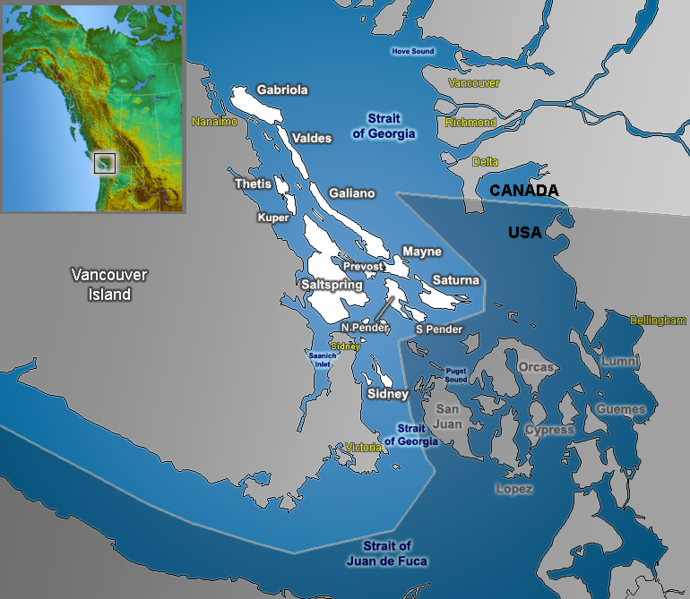
File:Gulf Islands map.png
外觀

預覽大小:690 × 599 像素。 其他解析度:276 × 240 像素 | 553 × 480 像素 | 770 × 669 像素。
原始檔案 (770 × 669 像素,檔案大小:288 KB,MIME 類型:image/png)
檔案歷史
點選日期/時間以檢視該時間的檔案版本。
| 日期/時間 | 縮圖 | 尺寸 | 用戶 | 備註 | |
|---|---|---|---|---|---|
| 目前 | 2006年9月22日 (五) 13:39 |  | 770 × 669(288 KB) | Qyd | move inset, add cities |
| 2006年8月30日 (三) 18:40 |  | 770 × 669(285 KB) | Qyd | fix typo | |
| 2006年8月8日 (二) 01:32 |  | 770 × 669(285 KB) | Qyd | lesser effects | |
| 2006年8月8日 (二) 01:08 |  | 770 × 669(287 KB) | Qyd | {{Information |Description=Map of Gulf Islands (British Columbia) in the Strat of Georgia |Source=GIS data |Date=Aug 2006 |Author=Qyd |Permission=All |other_versions= }} Category:Maps of British Columbia Category:Vancouver Island |
檔案用途
下列3個頁面有用到此檔案:
全域檔案使用狀況
以下其他 wiki 使用了這個檔案:
- ar.wikipedia.org 的使用狀況
- ast.wikipedia.org 的使用狀況
- bg.wikipedia.org 的使用狀況
- da.wikipedia.org 的使用狀況
- de.wikipedia.org 的使用狀況
- en.wikipedia.org 的使用狀況
- eo.wikipedia.org 的使用狀況
- es.wikipedia.org 的使用狀況
- fa.wikipedia.org 的使用狀況
- fr.wikipedia.org 的使用狀況
- id.wikipedia.org 的使用狀況
- ja.wikipedia.org 的使用狀況
- nl.wikipedia.org 的使用狀況
- pt.wikipedia.org 的使用狀況
- ro.wikipedia.org 的使用狀況
- ru.wikipedia.org 的使用狀況
- sv.wikipedia.org 的使用狀況
- www.wikidata.org 的使用狀況


