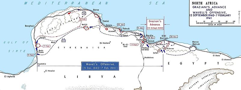
File:AfricaMap1.jpg
外觀

預覽大小:800 × 300 像素。 其他解析度:320 × 120 像素 | 1,202 × 451 像素。
原始檔案 (1,202 × 451 像素,檔案大小:101 KB,MIME 類型:image/jpeg)
檔案歷史
點選日期/時間以檢視該時間的檔案版本。
| 日期/時間 | 縮圖 | 尺寸 | 用戶 | 備註 | |
|---|---|---|---|---|---|
| 目前 | 2011年3月27日 (日) 13:52 | 1,202 × 451(101 KB) | Hohum | cleanup | |
| 2007年5月6日 (日) 13:36 | 1,202 × 451(128 KB) | Chanueting | {{Information |Description=Graziani's advance and Wavell's offensive -- en:September 13, en:1940 - en:February 7, en:1941 Source: US ARMY License: US Government document. Printed by the Government printing office. Assumed public doma |
檔案用途
下列3個頁面有用到此檔案:
全域檔案使用狀況
以下其他 wiki 使用了這個檔案:
- ar.wikipedia.org 的使用狀況
- azb.wikipedia.org 的使用狀況
- bg.wikipedia.org 的使用狀況
- ca.wikipedia.org 的使用狀況
- da.wikipedia.org 的使用狀況
- de.wikipedia.org 的使用狀況
- en.wikipedia.org 的使用狀況
- Military history of Italy during World War II
- Richard O'Connor
- Via della Vittoria
- Western Desert campaign
- Beda Fomm
- Australia in World War II
- Portal:Military history of Australia
- Battle of Beda Fomm
- Maletti Group
- Combeforce
- User:Ian Rose/Draft3
- File talk:AfricaMap1.jpg
- Battle of Sidi Barrani
- Southern Rhodesia in World War II
- Attack on Nibeiwa
- German radio intelligence operations during World War II
- British capture of Tobruk
- en.wikibooks.org 的使用狀況
- es.wikipedia.org 的使用狀況
- fa.wikipedia.org 的使用狀況
- fi.wikipedia.org 的使用狀況
- fr.wikipedia.org 的使用狀況
檢視此檔案的更多全域使用狀況。


