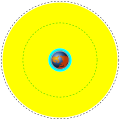
File:Orbits around earth scale diagram.svg
外觀

此 SVG 檔案的 PNG 預覽的大小:600 × 600 像素。 其他解析度:240 × 240 像素 | 480 × 480 像素 | 768 × 768 像素 | 1,024 × 1,024 像素 | 2,048 × 2,048 像素 | 4,300 × 4,300 像素。
原始檔案 (SVG 檔案,表面大小:4,300 × 4,300 像素,檔案大小:5 KB)
檔案歷史
點選日期/時間以檢視該時間的檔案版本。
| 日期/時間 | 縮圖 | 尺寸 | 用戶 | 備註 | |
|---|---|---|---|---|---|
| 目前 | 2014年3月30日 (日) 19:06 |  | 4,300 × 4,300(5 KB) | XZise | fixed rotation of Earth (is now looking from above) |
| 2014年3月30日 (日) 15:27 |  | 4,300 × 4,300(3 KB) | XZise | manually rewritten from scratch thus dramatically reduced file size | |
| 2008年1月16日 (三) 23:19 |  | 3,009 × 3,009(19 KB) | Mike1024 | {| class="wikitable" style="text-align:center" |- ! English !! Deutsch !! Français !! Marker !! Distance above earth (km) |!!Distance from center of earth (km) |- ! Earth !! Erde !! Terre | Blue/brown image || 0 | |
檔案用途
全域檔案使用狀況
以下其他 wiki 使用了這個檔案:
- ar.wikipedia.org 的使用狀況
- ast.wikipedia.org 的使用狀況
- bn.wikipedia.org 的使用狀況
- ca.wikipedia.org 的使用狀況
- cs.wikipedia.org 的使用狀況
- da.wikipedia.org 的使用狀況
- de.wikipedia.org 的使用狀況
- el.wikipedia.org 的使用狀況
- en.wikipedia.org 的使用狀況
- en.wikiversity.org 的使用狀況
- eo.wikipedia.org 的使用狀況
- es.wikipedia.org 的使用狀況
- et.wikipedia.org 的使用狀況
- eu.wikipedia.org 的使用狀況
- fa.wikipedia.org 的使用狀況
- fi.wikipedia.org 的使用狀況
- fr.wikipedia.org 的使用狀況
- he.wikipedia.org 的使用狀況
- hi.wikipedia.org 的使用狀況
- hr.wikipedia.org 的使用狀況
- hu.wikipedia.org 的使用狀況
- it.wikipedia.org 的使用狀況
檢視此檔案的更多全域使用狀況。

