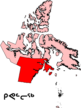
File:Nunavut Kivalliq Region.png
外觀
Nunavut_Kivalliq_Region.png (320 × 425 像素,檔案大小:11 KB,MIME 類型:image/png)
檔案歷史
點選日期/時間以檢視該時間的檔案版本。
| 日期/時間 | 縮圖 | 尺寸 | 用戶 | 備註 | |
|---|---|---|---|---|---|
| 目前 | 2006年8月16日 (三) 19:58 |  | 320 × 425(11 KB) | TeVe | {{Information |Description=Map of Kivalliq Region in Nunavut, Canada |Source=[http://en.wikipedia.org/wiki/Image:Nunavut_Kivalliq_Region.png English Wikipedia] |Date=2 August 2004 |Author=en:User:Keith Edkins |Permission=GFDL content from English Wik |
檔案用途
下列2個頁面有用到此檔案:
全域檔案使用狀況
以下其他 wiki 使用了這個檔案:
- ar.wikipedia.org 的使用狀況
- ast.wikipedia.org 的使用狀況
- ca.wikipedia.org 的使用狀況
- de.wikipedia.org 的使用狀況
- en.wikipedia.org 的使用狀況
- Kasba Lake
- Qikiqtaaluk (Foxe Basin)
- Nagjuttuuq
- Baker Lake (Nunavut)
- Wager Bay
- Aberdeen Lake (Nunavut)
- Keewatin Region
- Chesterfield Inlet
- Iqalugaarjuup Nunanga Territorial Park
- Cape Fullerton
- McConnell River Migratory Bird Sanctuary
- Beverly Lake (Nunavut)
- Yathkyed Lake
- Kaminak Lake
- Tavani, Nunavut
- Ferguson River (Nunavut)
- Comer Strait
- Frozen Strait
- Roes Welcome Sound
- Pitsiulartok
- Promise Island
- McConnell River
- Aiqqujat Islands
- Ascension Islands
- Inuujarvik Territorial Park
- Bell Peninsula
- Back Peninsula
- Mount Minto (Nunavut)
- Deer Island (Kivalliq Region)
- Boulder Island
- Centre Island (Nunavut)
- Camp Cove Island
- Iripajuk Island
- South Imilit Island
- North Imilit Island
- Moor Island
- Apqusiurniq Island
- Hanbury Island
- Rockhouse Island
- Akreavenek Island
- Pintail Island
- Reference Island
- South Midway Island
檢視此檔案的更多全域使用狀況。


