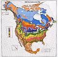
File:USDA Hardiness zone map.jpg
外觀

預覽大小:601 × 599 像素。 其他解析度:241 × 240 像素 | 481 × 480 像素 | 770 × 768 像素 | 1,027 × 1,024 像素 | 2,054 × 2,048 像素 | 4,014 × 4,002 像素。
原始檔案 (4,014 × 4,002 像素,檔案大小:5.92 MB,MIME 類型:image/jpeg)
檔案歷史
點選日期/時間以檢視該時間的檔案版本。
| 日期/時間 | 縮圖 | 尺寸 | 使用者 | 備註 | |
|---|---|---|---|---|---|
| 目前 | 2013年1月22日 (二) 00:21 |  | 4,014 × 4,002(5.92 MB) | Mapmarks | printable size, ca 4000 × 4000 px download from http://planthardiness.ars.usda.gov/PHZMWeb/Images/northamerica.jpg |
| 2008年10月15日 (三) 00:49 |  | 588 × 587(238 KB) | Omegatron | perspective skew and crop - way too low resolution, though [using an external editor] | |
| 2006年12月31日 (日) 15:14 |  | 620 × 603(165 KB) | SB Johnny | {{Information |Description=USDA Hardiness Zones in the US |Source=USDA website: http://www.usna.usda.gov/Hardzone/ushzmap.html |Date=copied 2006-12-31 |Author= |Permission=Public Domain |other_versions= }} {{PD-USGov}} |
檔案用途
下列頁面有用到此檔案:
全域檔案使用狀況
以下其他 wiki 使用了這個檔案:
- ca.wikipedia.org 的使用狀況
- en.wikipedia.org 的使用狀況
- en.wikibooks.org 的使用狀況
- et.wikipedia.org 的使用狀況
- fa.wikipedia.org 的使用狀況
- fi.wikipedia.org 的使用狀況
- fr.wikipedia.org 的使用狀況
- he.wikipedia.org 的使用狀況
- hu.wikipedia.org 的使用狀況
- pl.wikipedia.org 的使用狀況


