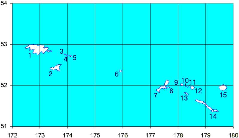
File:Western Aleutians.png
外观

本预览的尺寸:800 × 463像素。 其他分辨率:320 × 185像素 | 826 × 478像素。
原始文件 (826 × 478像素,文件大小:10 KB,MIME类型:image/png)
文件历史
点击某个日期/时间查看对应时刻的文件。
| 日期/时间 | 缩略图 | 大小 | 用户 | 备注 | |
|---|---|---|---|---|---|
| 当前 | 2008年9月19日 (五) 15:12 |  | 826 × 478(10 KB) | Thingg | clarify number 10 and 11 |
| 2005年8月4日 (四) 19:58 |  | 826 × 478(7 KB) | Urhixidur | Map of the Western Aleutian Islands. Prepared from Digital Chart of the World (DCW) data. Latitudes are North, longitudes are East. The 52nd parallel is to scale. 1-5 - Near Islands 1 - Attu Island 2 - Agattu Island 3-5 - Semichi Islands 3 - Alaid Island |
文件用途
以下10个页面使用本文件:
全域文件用途
以下其他wiki使用此文件:
- ast.wikipedia.org上的用途
- az.wikipedia.org上的用途
- ca.wikipedia.org上的用途
- ceb.wikipedia.org上的用途
- cs.wikipedia.org上的用途
- de.wikipedia.org上的用途
- en.wikipedia.org上的用途
查看此文件的更多全域用途。

