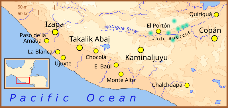
File:Formative Period southern Mesoamerica 2.svg
外观

此SVG文件的PNG预览的大小:800 × 380像素。 其他分辨率:320 × 152像素 | 640 × 304像素 | 1,024 × 486像素 | 1,280 × 608像素 | 2,560 × 1,215像素 | 1,241 × 589像素。
原始文件 (SVG文件,尺寸为1,241 × 589像素,文件大小:252 KB)
文件历史
点击某个日期/时间查看对应时刻的文件。
| 日期/时间 | 缩略图 | 大小 | 用户 | 备注 | |
|---|---|---|---|---|---|
| 当前 | 2008年2月9日 (六) 01:22 |  | 1,241 × 589(252 KB) | Madman2001 | Fixed mistake and added another site |
| 2008年2月7日 (四) 18:04 |  | 1,241 × 589(252 KB) | Madman2001 | fixed earlier mistake | |
| 2008年2月7日 (四) 17:41 |  | 1,241 × 589(224 KB) | Madman2001 | smaller formating changes | |
| 2008年2月7日 (四) 13:14 |  | 1,241 × 589(234 KB) | Madman2001 | {{Information |Description=A map of the southern-most area of Mesoamerica, showing important Formative Period sites. |Source=self-made |Date=February 2008 |Author= Madman2001 |Permission= |other_versions= }} |
文件用途
以下3个页面使用本文件:
全域文件用途
以下其他wiki使用此文件:
- af.wikipedia.org上的用途
- ar.wikipedia.org上的用途
- be.wikipedia.org上的用途
- bs.wikipedia.org上的用途
- de.wikipedia.org上的用途
- en.wikipedia.org上的用途
- Quiriguá
- Kaminaljuyu
- Takalik Abaj
- User talk:Madman2001
- Monte Alto culture
- Ujuxte
- Museo Popol Vuh
- User talk:Jonathan Kaplan1938
- Southern Maya area
- User:Mquinon2/Popol Vuh Museum Draft
- Potbelly sculpture
- Preclassic Maya
- Third Tikal–Calakmul War
- Regional communications in ancient Mesoamerica
- Kingdom of Shukuup
- es.wikipedia.org上的用途
- fi.wikipedia.org上的用途
- fi.wikibooks.org上的用途
- fr.wikipedia.org上的用途
- he.wikipedia.org上的用途
- hr.wikipedia.org上的用途
- hu.wikipedia.org上的用途
- id.wikipedia.org上的用途
- it.wikipedia.org上的用途
- ja.wikipedia.org上的用途
- ka.wikipedia.org上的用途
- lt.wikipedia.org上的用途
- nl.wikipedia.org上的用途
- pt.wikipedia.org上的用途
- ru.wikipedia.org上的用途
查看此文件的更多全域用途。

