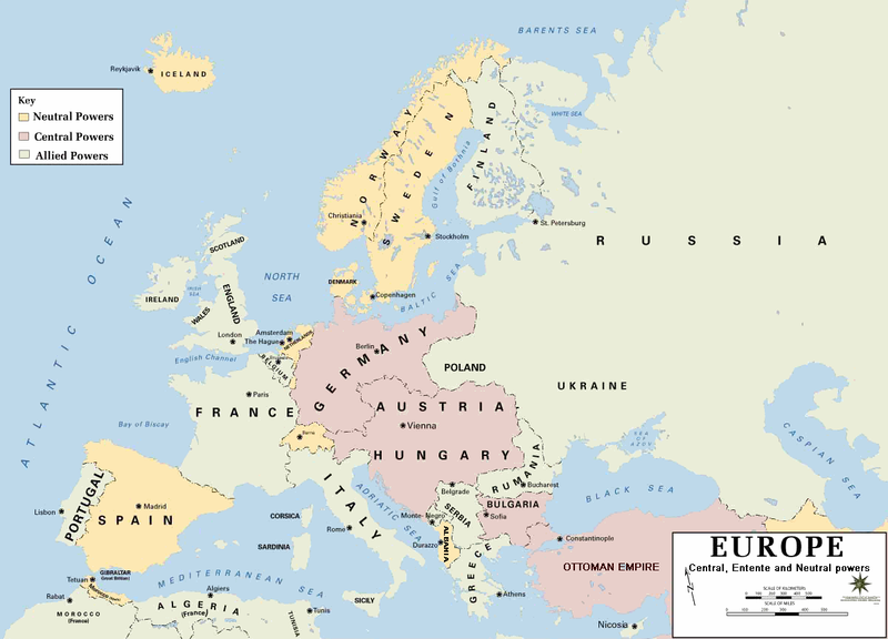
File:Europe 1914.png
外观

本预览的尺寸:800 × 576像素。 其他分辨率:320 × 230像素 | 640 × 460像素 | 1,024 × 737像素 | 1,194 × 859像素。
原始文件 (1,194 × 859像素,文件大小:287 KB,MIME类型:image/png)
文件历史
点击某个日期/时间查看对应时刻的文件。
| 日期/时间 | 缩略图 | 大小 | 用户 | 备注 | |
|---|---|---|---|---|---|
| 当前 | 2011年2月18日 (五) 21:30 |  | 1,194 × 859(287 KB) | Ras67 | cropped and squeezed |
| 2011年2月18日 (五) 18:53 |  | 1,198 × 863(636 KB) | DrKay | spelling corrections | |
| 2011年2月18日 (五) 08:26 |  | 1,198 × 863(636 KB) | DrKay | correcting some of the errors | |
| 2010年7月4日 (日) 03:24 |  | 1,194 × 859(236 KB) | Ras67 | cropped | |
| 2008年1月29日 (二) 22:56 |  | 1,198 × 863(719 KB) | Mahahahaneapneap | pngcrushed | |
| 2006年8月4日 (五) 08:23 |  | 1,198 × 863(726 KB) | Wassily | *Description: '''''Europe 1914''''' *Source: [http://www.dean.usma.edu/history/web03/atlases/great%20war/great%20war%20%20pages/great%20war%20map%2002.htm www.dean.usma.edu] *Background information: ''In 1938 the predecessors of what is today The Depart |
文件用途
以下页面使用本文件:
全域文件用途
以下其他wiki使用此文件:
- af.wikipedia.org上的用途
- als.wikipedia.org上的用途
- bs.wikipedia.org上的用途
- ckb.wikipedia.org上的用途
- da.wikipedia.org上的用途
- de.wikipedia.org上的用途
- en.wikipedia.org上的用途
- fi.wikipedia.org上的用途
- fo.wikipedia.org上的用途
- fr.wikipedia.org上的用途
- fy.wikipedia.org上的用途
- he.wikipedia.org上的用途
- hu.wikipedia.org上的用途
- is.wikipedia.org上的用途
- it.wikipedia.org上的用途
- ko.wikipedia.org上的用途
- mk.wikipedia.org上的用途
- nds.wikipedia.org上的用途
- nl.wikipedia.org上的用途
- nn.wikipedia.org上的用途
- rm.wikipedia.org上的用途
- simple.wikipedia.org上的用途
- si.wikipedia.org上的用途
- sl.wikipedia.org上的用途
- sr.wikipedia.org上的用途
- stq.wikipedia.org上的用途
- th.wikipedia.org上的用途
- uk.wikipedia.org上的用途


