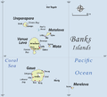
File:Womtelo Map-Banks-Vanuatu 1000.png
外观

本预览的尺寸:667 × 600像素。 其他分辨率:267 × 240像素 | 534 × 480像素 | 1,001 × 900像素。
原始文件 (1,001 × 900像素,文件大小:182 KB,MIME类型:image/png)
文件历史
点击某个日期/时间查看对应时刻的文件。
| 日期/时间 | 缩略图 | 大小 | 用户 | 备注 | |
|---|---|---|---|---|---|
| 当前 | 2010年11月23日 (二) 05:46 |  | 1,001 × 900(182 KB) | Womtelo | {{Information |Description={{en|1=I have drawn this map of the Banks Islands (Vanuatu) based on several other maps showing sufficient precision. I paid special attention to the transcription of place names, based on personal fieldwork in the Banks Islands |
文件用途
全域文件用途
以下其他wiki使用此文件:
- arz.wikipedia.org上的用途
- be.wikipedia.org上的用途
- bg.wikipedia.org上的用途
- ceb.wikipedia.org上的用途
- de.wikipedia.org上的用途
- en.wikipedia.org上的用途
- eo.wikipedia.org上的用途
- es.wikipedia.org上的用途
- fa.wikipedia.org上的用途
- fi.wikipedia.org上的用途
- fr.wikipedia.org上的用途
- gl.wikipedia.org上的用途
- id.wikipedia.org上的用途
- incubator.wikimedia.org上的用途
- it.wikipedia.org上的用途
- ka.wikipedia.org上的用途
查看此文件的更多全域用途。


