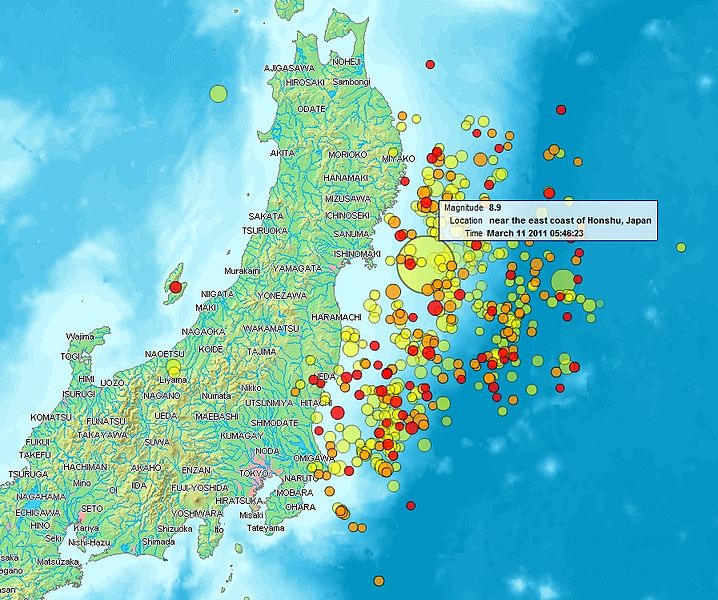
File:Map of Sendai Earthquake 2011.jpg
外观

本预览的尺寸:718 × 600像素。 其他分辨率:288 × 240像素 | 575 × 480像素 | 897 × 749像素。
原始文件 (897 × 749像素,文件大小:606 KB,MIME类型:image/jpeg)
文件历史
点击某个日期/时间查看对应时刻的文件。
| 日期/时间 | 缩略图 | 大小 | 用户 | 备注 | |
|---|---|---|---|---|---|
| 当前 | 2011年3月14日 (一) 21:31 |  | 897 × 749(606 KB) | Heinz-Josef Lücking | 14.3 + legend description |
| 2011年3月13日 (日) 04:27 |  | 1,362 × 1,386(1.41 MB) | Stanqo | 4h05m UTC, 13.03.2011 | |
| 2011年3月12日 (六) 11:10 |  | 1,197 × 1,245(885 KB) | Yuma | higher resol. | |
| 2011年3月12日 (六) 10:27 |  | 928 × 694(470 KB) | Yuma | update | |
| 2011年3月11日 (五) 17:20 |  | 1,006 × 773(596 KB) | Heinz-Josef Lücking | actual 2011-03-11 18:20 | |
| 2011年3月11日 (五) 11:19 |  | 1,014 × 779(598 KB) | Erdbeben20110311 | actuality | |
| 2011年3月11日 (五) 09:39 |  | 1,009 × 683(522 KB) | Erdbeben20110311 | {{Information |Description ={{en|1=Map of the Senadai Earthquake 2011}} |Source =http://www2.demis.nl/quakes/ |Author =www2.demis.nl |Date =2011-03-11 |Permission = |other_versions = }} Public domain according to http://ww |
文件用途
以下75个页面使用本文件:
- 2011年3月9日三陆近海地震
- 2011年4月宫城地震
- 2011年4月福島地震
- 2011年日本东北地方太平洋近海地震人道主义反应
- 2011年日本东北地方太平洋近海地震前震和余震
- 2011年日本東北地方太平洋近海地震
- 2011年茨城地震
- 2012年12月三陆近海地震
- 2012年岩手地震
- 2017年10月6日福岛近海地震 (17时00分)
- 2017年10月6日福岛近海地震 (23时56分)
- 2021年宫城地震
- 2021年福岛地震
- FNS音樂特別節目 昂首闊步向前行 ~歌聲連起日本~
- Let's try again
- 三陸鐵道
- 不要輸給心痛
- 东海第二核电站
- 仙台市
- 仙台機場
- 仙台火力發電廠
- 北茨城市
- 南三陸町
- 南相馬市
- 原町火力發電廠
- 吉田昌郎
- 因2011年日本东北地方太平洋近海地震严重破坏城镇
- 國道288號 (日本)
- 國道6號 (日本)
- 大槌町
- 大船渡市
- 大船渡線
- 女川核电站
- 宮古市
- 山田町
- 市原市
- 常磐線
- 愛心無國界311燭光晚會
- 新地發電廠
- 新地站
- 日本對福島核電廠事故的反應
- 日本核能
- 東北新幹線
- 東日本大震災
- 東松島市
- 枝野幸男
- 栗原市
- 氣仙沼市
- 氣仙沼線
- 濱岡核電廠
- 為了誰 -What can I do for someone?-
- 盲搶鹽事件
- 相信希望fight & smile賑災募款晚會
- 石卷市
- 石卷日日新聞
- 福岛50死士
- 福岛第一核电站事故
- 福岛第一核电站事故反应堆详细状况
- 福島核廢水排放問題
- 福島核廢水排放後續國際反應
- 福島第一核電廠
- 福島第一核電廠事故時間軸
- 福島第一核電廠事故的輻射影響
- 福島第二核電廠
- 科斯莫石油公司
- 臺灣對東日本大震災之援助及各界反應
- 藤沼大坝
- 謝謝臺灣計畫
- 釜石市
- 陸前高田市
- 雙葉町
- 风的电话
- User:J87j8787/28
- User:J87j8787/30
- Template:2011年日本东北地方太平洋近海地震
全域文件用途
以下其他wiki使用此文件:
- af.wikipedia.org上的用途
- als.wikipedia.org上的用途
- ar.wikipedia.org上的用途
- ast.wikipedia.org上的用途
- az.wikipedia.org上的用途
- bat-smg.wikipedia.org上的用途
- bcl.wikipedia.org上的用途
- be-tarask.wikipedia.org上的用途
- be.wikipedia.org上的用途
- ca.wikipedia.org上的用途
- cu.wikipedia.org上的用途
- da.wikipedia.org上的用途
- de.wikipedia.org上的用途
- el.wikipedia.org上的用途
- en.wikipedia.org上的用途
- en.wikibooks.org上的用途
- eo.wikipedia.org上的用途
- es.wikipedia.org上的用途
- es.wikinews.org上的用途
- eu.wikipedia.org上的用途
- fi.wikipedia.org上的用途
- fr.wikipedia.org上的用途
- ga.wikipedia.org上的用途
- he.wikipedia.org上的用途
- hr.wikipedia.org上的用途
- hu.wikipedia.org上的用途
- id.wikipedia.org上的用途
- is.wikipedia.org上的用途
- it.wikinews.org上的用途
- ja.wikipedia.org上的用途
- ko.wikipedia.org上的用途
- ksh.wikipedia.org上的用途
- lt.wikipedia.org上的用途
- mrj.wikipedia.org上的用途
- ms.wikipedia.org上的用途
- nl.wikipedia.org上的用途
- nn.wikipedia.org上的用途
- no.wikipedia.org上的用途
查看此文件的更多全域用途。

