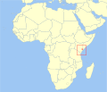
File:Beatragus hunteri distribution.svg
外观

此SVG文件的PNG预览的大小:501 × 430像素。 其他分辨率:280 × 240像素 | 559 × 480像素 | 895 × 768像素 | 1,193 × 1,024像素 | 2,386 × 2,048像素。
原始文件 (SVG文件,尺寸为501 × 430像素,文件大小:111 KB)
文件历史
点击某个日期/时间查看对应时刻的文件。
| 日期/时间 | 缩略图 | 大小 | 用户 | 备注 | |
|---|---|---|---|---|---|
| 当前 | 2020年7月8日 (三) 21:45 |  | 501 × 430(111 KB) | Hogweard | South Sudan border |
| 2010年11月6日 (六) 15:24 |  | 501 × 430(101 KB) | Mysid | == Summary == {{valid SVG}} {{Information |Description={{en|1=Geographic distribution of the en:Hirola (''Beatragus hunteri'').}} {{fi|1=Hirolan eli hunterinantiloopin (''Beatragus hunteri'') levinneisyysalue.}} |Source=Put together by [[w:User:Mysi |
文件用途
以下页面使用本文件:
全域文件用途
以下其他wiki使用此文件:
- af.wikipedia.org上的用途
- ar.wikipedia.org上的用途
- arz.wikipedia.org上的用途
- avk.wikipedia.org上的用途
- bg.wikipedia.org上的用途
- ca.wikipedia.org上的用途
- ceb.wikipedia.org上的用途
- cs.wikipedia.org上的用途
- de.wikipedia.org上的用途
- en.wikipedia.org上的用途
- es.wikipedia.org上的用途
- eu.wikipedia.org上的用途
- fa.wikipedia.org上的用途
- fi.wikipedia.org上的用途
- fr.wikipedia.org上的用途
- gd.wikipedia.org上的用途
- gl.wikipedia.org上的用途
- he.wikipedia.org上的用途
- hu.wikipedia.org上的用途
- id.wikipedia.org上的用途
- ko.wikipedia.org上的用途
- ml.wikipedia.org上的用途
- nl.wikipedia.org上的用途
- nv.wikipedia.org上的用途
- pl.wikipedia.org上的用途
- pt.wikipedia.org上的用途
- ru.wikipedia.org上的用途
- sr.wikipedia.org上的用途
- sv.wikipedia.org上的用途
- uk.wikipedia.org上的用途
- vi.wikipedia.org上的用途
- www.wikidata.org上的用途


