跳转到内容

File:Typhoon Mawar 2005.jpg

页面内容不支持其他语言。
這個文件來自維基共享資源
维基百科,自由的百科全书

原始文件 (4,200 × 4,200像素,文件大小:2.61 MB,MIME类型:image/jpeg


摘要

描述

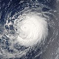
Typhoon Mawar is posing photogenically in this satellite image. The storm was far out in the northwestern Pacific Ocean, some 900 kilometers from Tokyo. It was traveling in parallel with Tropical Cyclone Guchol, both headed roughly northwest at comparable speeds. Mawar, however, will strike mainland Japan on its projected course, and will have built to a Category 4 storm with sustained winds of over 320 kilometers per hour (200 miles per hour) as it strikes shore around August 25. Guchol, however, will never come close to shore if current projections are correct, and will remain a substantially weaker system with peak winds less than half the speed of Typhoon Mawar.

The Moderate Resolution Imaging Spectroradiometer (MODIS) on NASA’s Terra satellite captured this image at 10:10 a.m. local time, on August 22, 2005. At this time, Mawar had peak winds around 200 km/hr (125 mph). This image was cropped from a larger image depicting both Mawar and Guchol.
日期
来源 http://visibleearth.nasa.gov/view_rec.php?id=7054
作者 Jeff Schmaltz, MODIS Rapid Response Team, NASA/GSFC
授权
(二次使用本文件)
Public domain 本文件完全由NASA创作,在美国属于公有领域。根据NASA的版权方针,NASA的材料除非另有声明否则不受版权保护。(参见Template:PD-USGov/zhNASA版权方针页面JPL图片使用方针。)
警告:
其他版本 Image:Mawar and Guchol 2005.jpg

说明

添加一行文字以描述该文件所表现的内容

此文件中描述的项目

描繪內容

文件历史

点击某个日期/时间查看对应时刻的文件。

日期/时间缩⁠略⁠图大小用户备注
当前2006年9月6日 (三) 18:082006年9月6日 (三) 18:08版本的缩略图4,200 × 4,200(2.61 MB)Good kitty== Summary == {{Information |Description= Typhoon Mawar is posing photogenically in this satellite image. The storm was far out in the northwestern Pacific Ocean, some 900 kilometers from Tokyo. They are traveling in parallel with Tropical Cyclone Guchol,

以下2个页面使用本文件:

全域文件用途

以下其他wiki使用此文件:

元数据