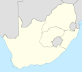
File:Map of South Africa with provincial borders 1976-1994.svg
外观

此SVG文件的PNG预览的大小:684 × 599像素。 其他分辨率:274 × 240像素 | 548 × 480像素 | 876 × 768像素 | 1,168 × 1,024像素 | 2,337 × 2,048像素 | 809 × 709像素。
原始文件 (SVG文件,尺寸为809 × 709像素,文件大小:389 KB)
文件历史
点击某个日期/时间查看对应时刻的文件。
| 日期/时间 | 缩略图 | 大小 | 用户 | 备注 | |
|---|---|---|---|---|---|
| 当前 | 2011年3月7日 (一) 17:19 |  | 809 × 709(389 KB) | Htonl | {{Information |Description ={{en|1=Blank map of South Africa, with the provincial boundaries as they were from 1976 (when Griqualand East was transferred from the Cape to Natal) to 1994 (when entirely new provinces were established). Projection: Lamber |
文件用途
没有页面链接到本图像。
全域文件用途
以下其他wiki使用此文件:
- he.wikipedia.org上的用途


